Mount Chocorua is a moderately difficult hike located at the southern end of NH’s White Mountains. Standing at 3,478 feet, it offers outstanding 360 degree views on its rocky and uniquely shaped summit. A perfect view to the north and west into the heart of the White Mountains, and the many surrounding lakes and peaks nearby.
- Height: 3,478 feet (1,060 meters)
- Length: 7.8-9 Miles Round Trip (12.55 – 14.48 km) – route options explained below
- Difficulty: Moderate
- Duration: 4-7 hours
Quick Navigation:
Trail Maps | Directions | Camping | Trail Conditions | History
Trails
Liberty Trail | 7.8 Miles (12.55 km) Round Trip
Parking off of Rt 16 next to Chocorua lake. This trail is 3.9 miles each way, 7.8 miles total (12.55 km). It offers a gradual incline and elevation gain of around 2,500 feet. It meets up with Jim Liberty Cabin .5 miles away from the summit, where you begin some rock scrambling. It features gorgeous views near the top with a few different cool cliff views. Parking information below. This trail will take 1.5 to 3 hours each way, depending on your hiking speed. The last section to the trailhead may not have been cleared of snow – making access difficult or impossible in winter.
Champney Falls Trail | 8.4 Miles (13.52 km) Round Trip
This trail offers gorgeous views as you walk past Champney Falls to Chocorua. Round trip around 8.4 (13.52 km) miles with about 2,300 feet of elevation gain. It is accessed from the Kancamagus highway. It is only shortly after the Rocky Gorge Scenic area coming from Route 16. There is a good sized parking lot at the trailhead. Directions below. This trail should take 2 to 3.5 hours each way depending upon your hiking speed. This is one of the primary winter routes up Chocorua.
Piper Trail | 9 Miles (14.48 km) Round Trip
This trailhead is located off of Route 16. With a 4.5 mile and 2,700 foot elevation gain to the summit, this trail is a great workout. See directions to this trail below. 9 miles total (14.48 km). This is one of the most common routes up Chocorua, and is one of the better winter options. The parking area during winter is located on private land, where the owner may ask for a small fee for the day.
Brook Trail | 7.2 Miles (11.59 km) Round Trip
This trail is 7.2 miles round trip with 2,300 feet of elevation gain. Many consider this slightly harder than the liberty trail. It also can be a bit slippery and dangerous in wet or icy weather. This trail can be accessed from the same parking lot as the Liberty Trail.
Carter Ledge Trail | 8.6 Miles (13.84 km) Round Trip
This trail is 8.6 miles round trip (4.3 to the summit) with around 2,700 feet of elevation gain. This is considered one of the most scenic routes up Chocorua. A common loop is to ascend the Carter Ledge, and descend the Hammond or Piper Trail. Carter ledge features gorgeous granite cliffs, and takes you over the gorgeous three sisters summits. You will get panoramic views at various points along the way to the summit.
How long does it take to hike Chocorua?
Champney Falls – 2 to 3.5 hours each way depending on your hiking speed. (8.4 miles total)
Liberty Trail – 2 to 5 hours each way. (7.8 miles total) – One of easiest routes
Piper Trail – 2 to 5 hours each way. (9 miles total) – One of easiest routes
Carter Ledge Trail – 3-5 hours each way (8.6 miles total)
Brook Trail – 2-5 hours each way (7.2 miles total)
Trail Maps
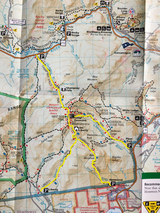
All trails up Chocorua (popular routes highlighted)
Piper and Carter Ledge Trail Map
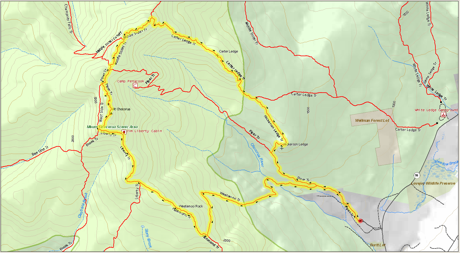
Piper and Carter Ledge Trail Map. (click to see full size)
Champney Falls Trail Map
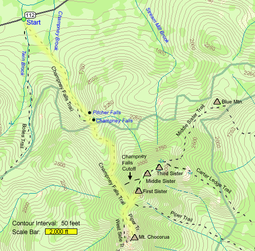
Champney Falls Trail Map (Click to see full image)
Winter Hiking Mount Chocorua
Mount Chocorua is an awesome winter hike. It is exposed at the summit, making the top windy and icy. Extra caution and preparation is needed in winter. Hikers should always bring microspikes on this hike, and snowshoes may be needed depending upon conditions.
The best routes in winter are via the Piper Trail and The Champney Falls Trail. These routes are the simplest, safest, and most easily accessed during the winter months.
Directions
To Kancamagus (Rt 112) Trailhead (Champney Falls Trail)
From Route 16, follow route 12 for 14 miles. The trailhead will be on your left with a noticeable parking lot.
To Chocorua Lake Trailhead
On Route 16, take the road to Chocorua lake, you will be able to see the lake and the small bridge crossing the narrow portion of the lake from Route 16. Follow the dirt road signs to the hiking trailhead. The signs mark the path well. In the winter, this road may not be maintained, and traveling via car may be impossible.
To Piper Trailhead
On Route 16, this trailhead is only a few miles after Chocorua lake.
Camping
Camping is prohibited in the forest protected areas of Chocorua, which are marked by signs on the trails. Anywhere below these areas, you can legally set up a tent. Basically, you have to stay at a relatively low elevation.
Jim Liberty Hut
The Jim Liberty hut has a table in it, as well as a few wooden beds that would be great to sleep on with a sleeping pad and sleeping bag.
You can also find camping at Camp Penacook (marked on map) where there are lean-to tent sites.
Trail Conditions
Mount Chocorua’s trails are generally in very good condition. They are well traveled, and pretty safe. During wet times, you can experience mud, and the rock scrambles can be a bit more dangerous and difficult to traverse. Simply be much safer during wet conditions. Winter hiking poses some concern as the summit is exposed to high winds, and is largely just rock, making for very icy and slippery surfaces. Exercise a lot of caution in these conditions and wear crampons/microspikes.
Weather Forecast
Whether is is rainy, sunny, snowy, or cloudy, Chocorua can be an awesome experience. . All are great options and offer a unique experience. Just simply be cautious and have the right equipment during times of year where the temperatures can cause icy, windy, or rainy conditions. Always be prepared with the proper gear.
Conway, NH
This Afternoon
Mostly sunny. High near 32, with temperatures falling to around 24 in the afternoon. West wind around 5 mph.
Tonight
Mostly clear, with a low around 16. West wind around 5 mph.
Monday
Sunny. High near 29, with temperatures falling to around 20 in the afternoon. Northwest wind around 5 mph.
Monday Night
Partly cloudy, with a low around 15. Northwest wind around 5 mph.
Tuesday
Partly sunny, with a high near 29. West wind around 5 mph.
Tuesday Night
Partly cloudy, with a low around 13.
Wednesday
Partly sunny, with a high near 28.
History of Mount Chocorua
Mount Chocorua is said to be named after a Native American chief (not confirmed) who resided in the area. There are various stories as to why the Mountain was named after him, that can be read about here.
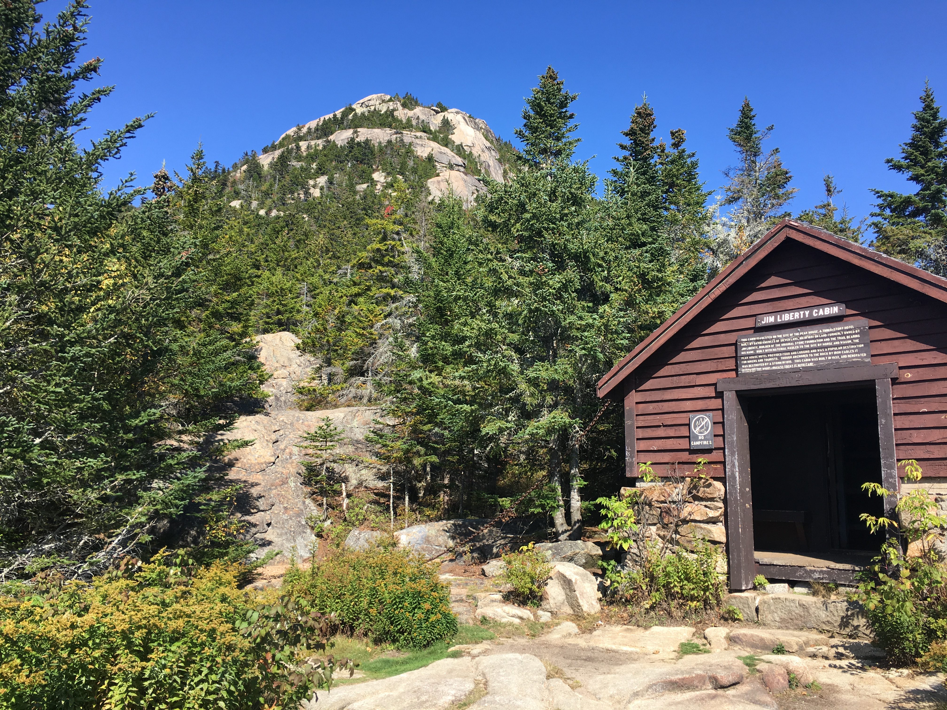
Jim Liberty Cabin
Pictures:
Max DesMarais is the founder of hikingandfishing.com. He has a passion for the outdoors and making outdoor education and adventure more accessible. Max is a published author for various outdoor adventure, travel, and marketing websites. He is an experienced hiker, backpacker, fly fisherman, backcountry skier, trail runner, and spends his free time in the outdoors. These adventures allow him to test gear, learn new skills, and experience new places so that he can educate others. Max grew up hiking all around New Hampshire and New England. He became obsessed with the New Hampshire mountains, and the NH 48, where he guided hikes and trail runs in the White Mountains. Since moving out west, Max has continued climbed all of the Colorado 14ers, is always testing gear, learning skills, gaining experience, and building his endurance for outdoor sports. You can read more about his experience here: hikingandfishing/about
That’s awesome! Probably had some great foliage too!
Great hike!
Had a blast hiking Chocorua! Incredible views at the peak. Stopped at the cabin to eat on the way back down.