Deseret Peak is a prominent peak in the Stansbury Mountains that features stunning views of the southern part of the Great Salt Lake.
Quick Navigation:
Trail Map | Trails | Hiking In Winter | Camping | Weather | Directions | Pictures
Difficulty – Strenuous
Distance – 7.77 miles round trip (12.5 km)
Height – 11,031 feet (3362 m)
Elevation gain – 3,576 feet (1090 m)
Duration – 5-6 hours (book time)
Trailhead Location – Deseret Peak Trailhead (Loop Campground)
Dogs – Allowed on leash
Need To Know Information
- This trailhead gets packed quickly on the weekends, so it may be necessary to park down the road at the nearest open spot.
- The road features both reserved and first come first serve campsites. You can reserve and find information on the Loop Campground here. The Upper Narrows and Lower Narrows campground along the road are both first come first serve campgrounds with self serve fee stations.
- The road to the trailhead is usually open May through October, and the inter months it is closed, and becomes a skiing destination.
My Experience
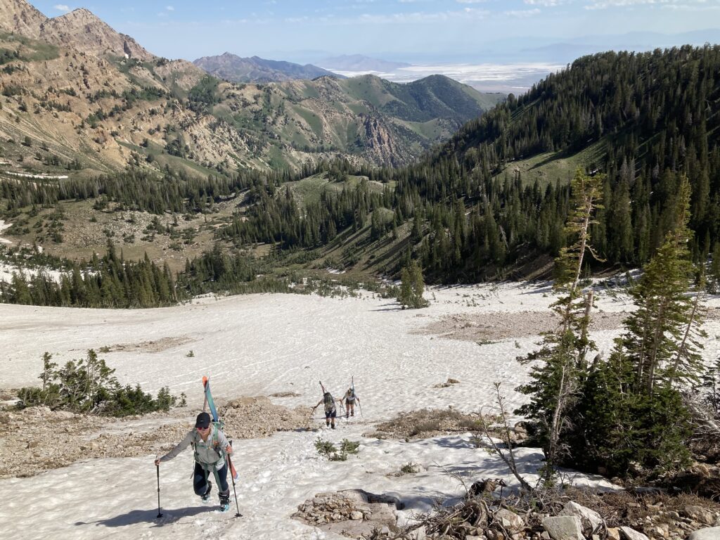
I, and a group of friends took a camping trip out to Deseret Peak where we reserved an amazing campsite for around 9 of us. The plan was to enjoy the camp, wake up in the morning, hike to Deseret Peak, and ski the remaining snow before hiking back to the car. It was an incredible time, and we had a blast as a group, and were able to summit Deseret with other hikers around, and ski both the twin couloirs.
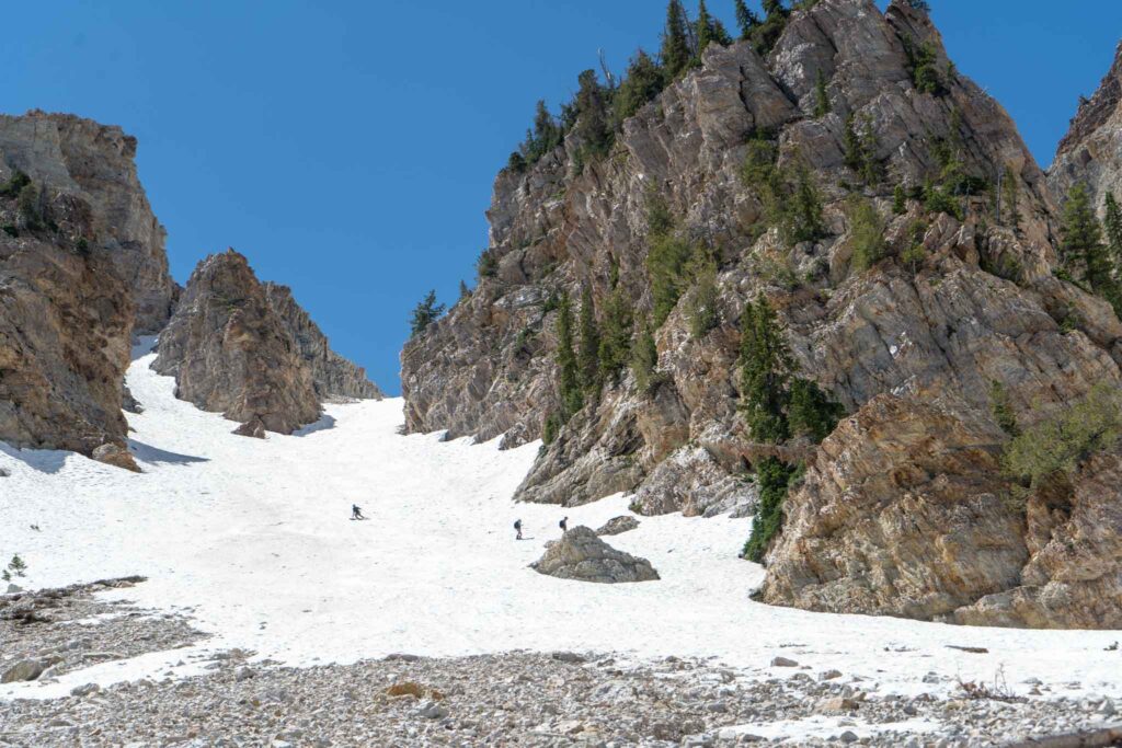
Me skiing on Deseret
Trail Map
Here is a link to the route that can be uploaded to your device.
Routes
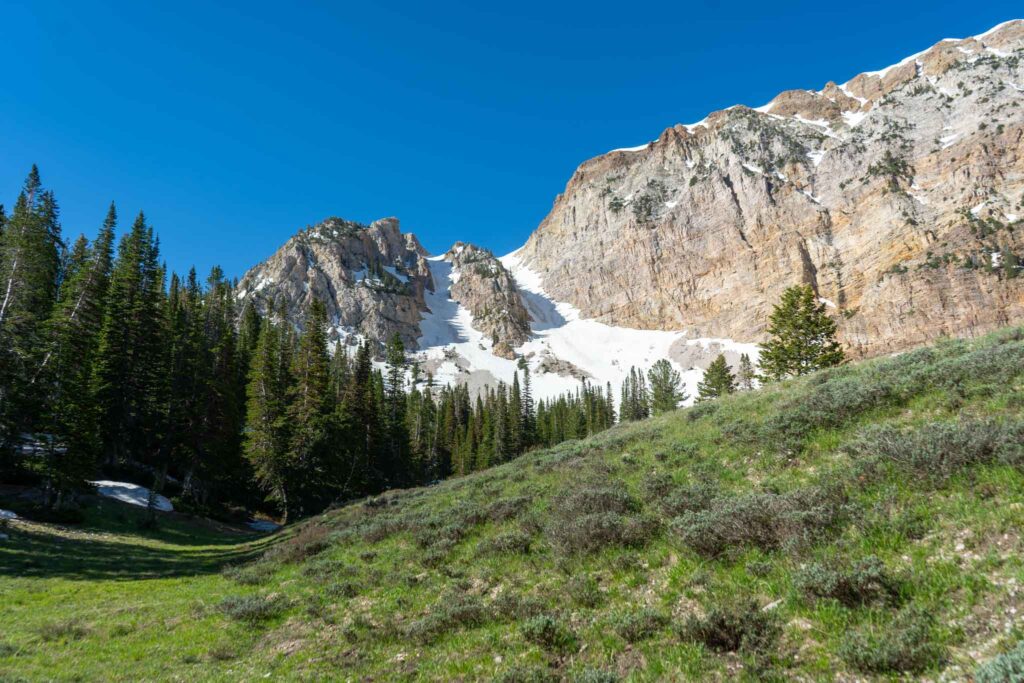
There are two common routes for reaching Deseret Peak. The Mill Fork Canyon Trail (#1752), or Dry Lakes Pocket Fork Trail (#1753) for a period of time before taking an unnamed trail, or skinning to the Twin Couloirs. We discuss both below.
Mill Fork Canyon Trail (#1752)
This is the primary route to the summit of Deseret, as most hikers take this approach. It is well traveled, easy to follow, and features gradual to moderate gains all the way to the summit. Hikers start at the Mill Fork trailhead and at 0.65 miles in, they cross a creek. It is at this creek crossing (just after crossing the creek) that hikers should bear left, and stay on the main trail. Hikers don’t hit another main junction for 3 miles.
From here, hikers bear right and continue ascending towards East Deseret Peak, and pass on the south side of that peak on a gradually inclining trail to Deseret Peak. They will pass the Twin Couloirs right after East Deseret Peak.
Dry Lakes Pocket Fork Trail (#1753)
Skiers will often take this route, as it is the fastest to get to the base of the Twin Couloirs and Temple Couloir. There is a well traveled trail that hikers can take up pretty far into the basin before the trail begins to disappear. From here, the route is still easy, but you’ll need to do some route finding.
Here is a Strava Link of our route:
Hiking in Winter
This is a common backcountry skiing zone, but because the road is closed in winter months, it is not well traveled. Hikers and skiers will need to travel 3 miles on the road to reach the trailhead in winter. It is often skinnable, or commonly, skiers will bring bikes to bike on the road depending upon the conditions.
Camping Information
This is an extremely common area for camping. You’ll find groups camping at many of the first come first serve areas, and ATVs and dirtbikes going up and down the road. As mentioned above, the road features both reserved and first come first serve campsites. You can reserve and find information on the Loop Campground here. The Upper Narrows and Lower Narrows campground along the road are both first come first serve campgrounds with self serve fee stations.
Weather
Here is a detailed weather forecast for the area:
Rush Valley, UT
Tonight
Mostly clear, with a low around 22. Northwest wind around 6 mph.
Sunday
Sunny. High near 31, with temperatures falling to around 24 in the afternoon. Northwest wind around 6 mph.
Sunday Night
Mostly clear. Low around 21, with temperatures rising to around 23 overnight. Northwest wind around 5 mph.
Monday
Mostly sunny, with a high near 29. Northwest wind around 5 mph.
Monday Night
Partly cloudy, with a low around 18. North northwest wind around 5 mph.
Tuesday
Sunny, with a high near 25.
Tuesday Night
Mostly clear, with a low around 17.
Directions
Additional Pictures
Views of the Great Salt Lake heading up Deseret Peak
Twin Couloirs Deseret Peak
Max DesMarais is the founder of hikingandfishing.com. He has a passion for the outdoors and making outdoor education and adventure more accessible. Max is a published author for various outdoor adventure, travel, and marketing websites. He is an experienced hiker, backpacker, fly fisherman, backcountry skier, trail runner, and spends his free time in the outdoors. These adventures allow him to test gear, learn new skills, and experience new places so that he can educate others. Max grew up hiking all around New Hampshire and New England. He became obsessed with the New Hampshire mountains, and the NH 48, where he guided hikes and trail runs in the White Mountains. Since moving out west, Max has continued climbed all of the Colorado 14ers, is always testing gear, learning skills, gaining experience, and building his endurance for outdoor sports. You can read more about his experience here: hikingandfishing/about
Amazing Day with perfect weather!
Lots of people hiking and camping along the road. We brought skis, booted up the Twin Couloirs, hit the summit, and then skied both lines before heading back to the car. We had a great large crew!