Yosemite National Park is home to some of the most stunning hikes in the country, with Yosemite Falls being one of the best. This iconic waterfall is a must do for anyone looking to explore the beauty of Yosemite National Park. In this article, we’ll cover everything you need to know before setting out to hike up to Yosemite Falls, or to the various viewpoint options. There are options for advanced, intermediate, and beginner level hikers.
Hike Stats For Hiking To Upper Yosemite Falls:
Difficulty – Difficulty
Distance – 7.6 miles (12 km) round trip
Height –3,967 feet (1,347m)
Elevation gain – 2,700 ft (823 m) elevation gain
Duration – 6-10 hours round trip
Hike Class: Class 2
Trailhead Location – Camp 4 (Shuttle stop 7) – Yosemite Falls Trailhead
Dogs – Not allowed
Need To Know Information
- A permit is required to enter Yosemite at many parts of the year: https://www.nps.gov/yose/planyourvisit/permitsandreservations.htmhttps://www.fs.usda.gov/recarea/arp/recarea/?recid=8080
- Additional permits are not required to hike this trail unless hikers are spending the night dispersed camping above the falls.
- You can hike to Yosemite Falls year round, but the trail is steep, and can get icey during many parts of the year where extra caution is needed.
- Not all hikers go to the top, there are various hikes and viewpoints for the falls that we will explain below.
Trail Map
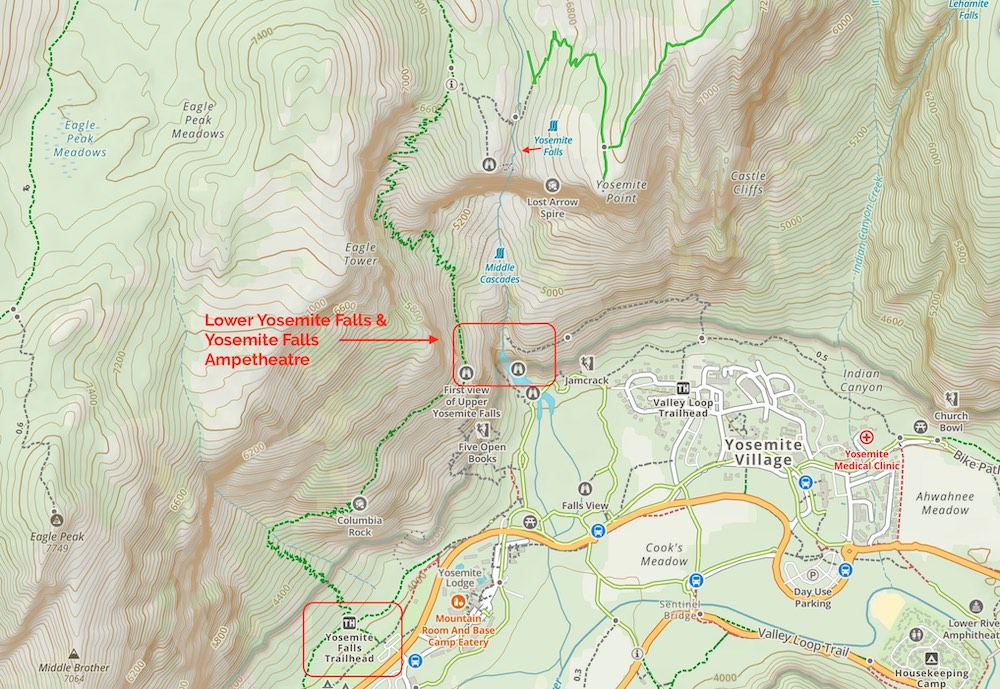
Routes
Visitors to the park have several options for hiking towards Yosemite Falls with amazing views, we are going to discuss each of those main points of interest.
Upper Yosemite Falls
Upper Yosemite Falls viewpoint
Distance: 8.72 Miles Round Trip (14.03 km)
Elevation Gain: 1,995 Feet (608.08 m)
Duration: 6-10 hours round trip
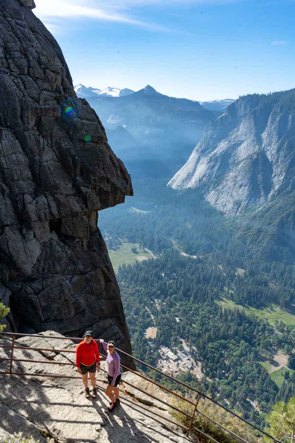
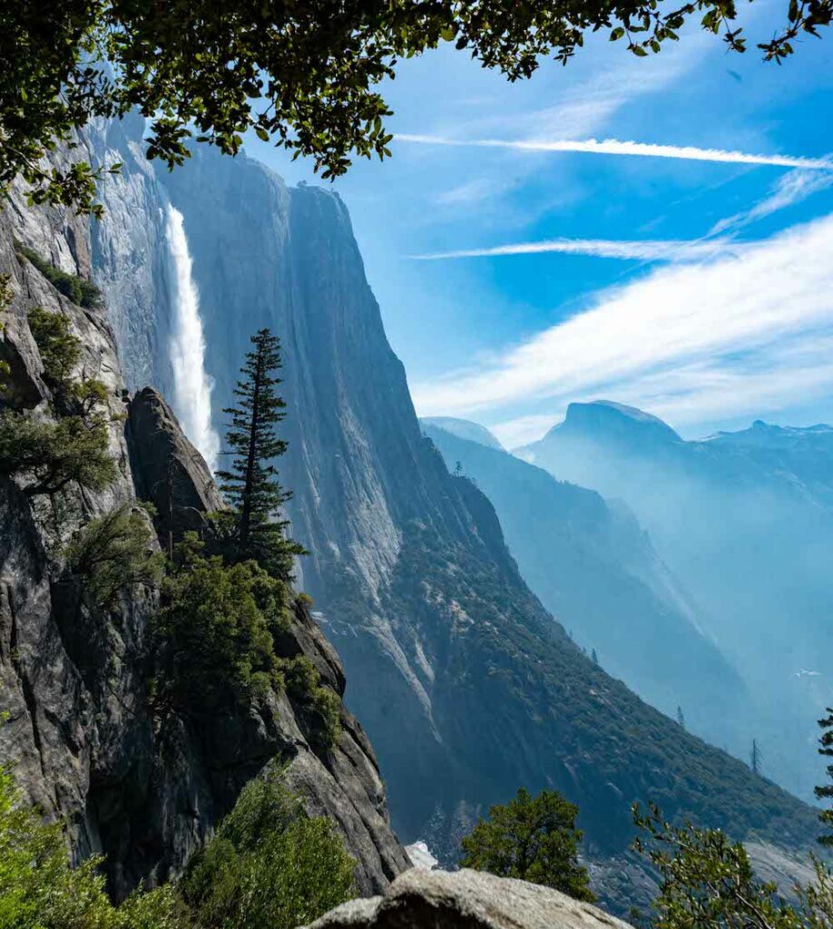
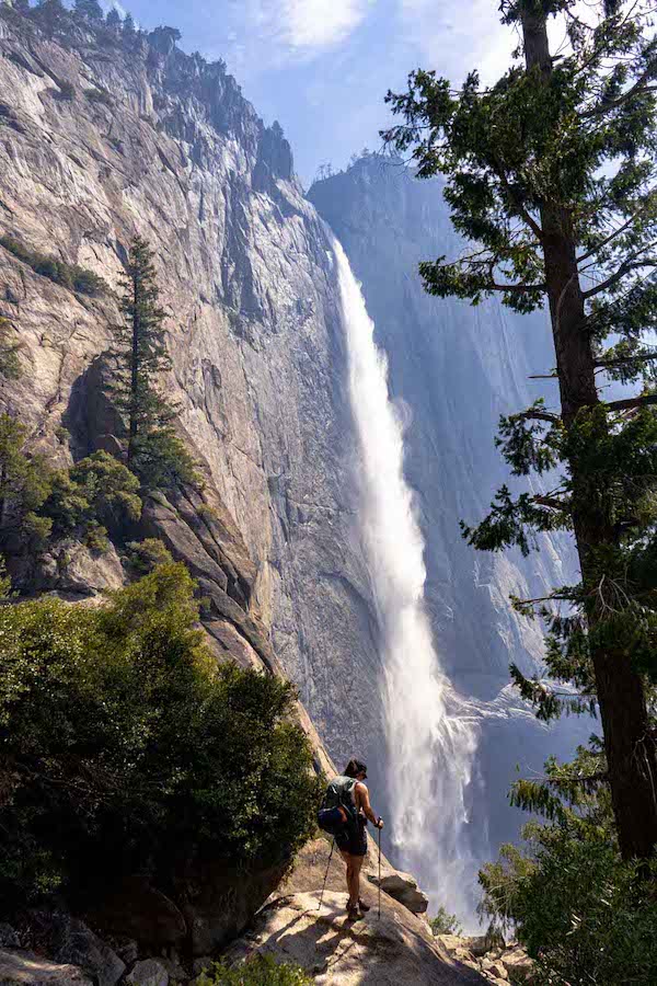
Upper Yosemite falls is one of the most common turnaround points. It takes you to the lower views of the falls, but then all the way next to the falls with incredible views. At the end of this hike, steep steps with metal railings have been installed that take hikers along the cliff side for even better views. This is not the place for people with a fear of heights, but it is sure to be one of the most incredible viewpoints and hiking experiences of your life.
Views Near Columbia Rock
Distance: 2 miles (3.2 km) round trip
Elevation: 1,000 ft (328 m) elevation gain
Difficulty: Moderate
Time: 2-3 hours round trip
Begin at: Camp 4 area (near shuttle stop #7)
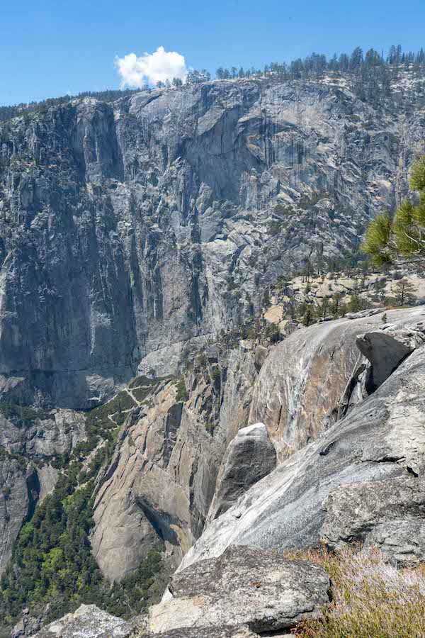
The Columbia Rock area is a great place for those who don’t have enough time, or don’t quite want to make it all the way the top of Yosemite Falls. In our opinion, some of the best views of the falls are from the first viewpoint along the trail all the way up to the falls here as it is a place that allows you to view the entire falls and much of the rest of the valley (pictures below). Hikers heading to the top of the falls, or to Yosemite point will first pass this section on the the trail. In addition, after this point, the hike starts to ascend even steeper, but there are countless incredibly good viewpoints.
Yosemite Point
Views from Yosemite Point looking back at the trail to Yosemite Falls
Distance: 8.4 miles (13.52 km)
Elevation Gain: 3,723 ft (1134.8 m)
Duration: 6-10 hours round trip
Begin at: Camp 4 area (near shuttle stop #7)
Yosemite point is usually combined with the Yosemite Falls viewpoint. Hiking to Yosemite point gives some of the best views into the valley, and of Half Dome. In our opinion, the only better view of Half Dome, is from North Dome. Hikers will hike to the upper falls, cross the river over a bridge, and continue to a viewpoint over the falls and valley below.
If you plan on hiking to Yosemite Point, we highly recommend also adding on the Upper Yosemite Falls viewpoint to this trip which will add about 1.8 miles round trip, and a few hundred feed of elevation gain and loss.
Lower Yosemite Falls
Distance: 1 mile (1.6 km) loop
Elevation Gain: 50 ft (15 m)
Difficulty: Easy
Duration: 30 minutes
Begin at: Valley Visitor Center, Shuttle Stop 6
This is a very simple route that is accessible for just about anyone. It takes visitors near the base of the falls where they can often even get wet from the spray of the falls. It features a great little loop, easy access, very little elevation gain, and incredibly good views. It will pretty much always be crowded, but the views from the bottom are simply incredible.
Hiking in Winter
Because much of the trail is south facing, in winter, this trail often can stay in much better shape than other trails in the park. It is accessible year round, but winter can create icey and dangerous trail conditions.
Camping Information
Nearby lodging and campground information can be found here.
And getting backcountry/wilderness camping permit info can be found here.
Weather
Here is a detailed weather forecast for the area:
Yosemite Valley, CA
This Afternoon
Partly sunny. High near 62, with temperatures falling to around 55 in the afternoon. Northeast wind around 0 mph.
Tonight
Mostly clear. Low around 40, with temperatures rising to around 42 overnight. Northeast wind 0 to 5 mph.
Monday
Sunny. High near 62, with temperatures falling to around 54 in the afternoon. North northwest wind around 0 mph.
Monday Night
Mostly clear, with a low around 38. Northeast wind 0 to 5 mph.
Tuesday
Sunny, with a high near 63. North northeast wind 0 to 5 mph.
Tuesday Night
Mostly clear, with a low around 38. North northeast wind 0 to 5 mph.
Wednesday
Sunny, with a high near 63. North northeast wind 0 to 5 mph.
Directions
Directions to Yosemite Falls Trailhead:
Additional Pictures
Yosemite Falls from the trail
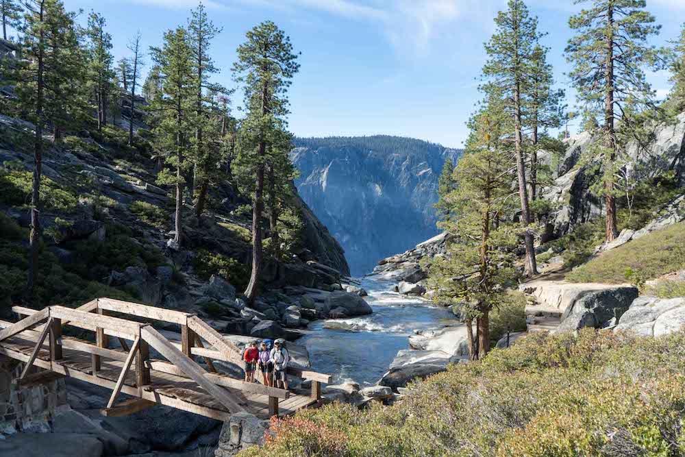
The bridge crossing the river between Yosemite Falls and Yosemite Point
Yosemite falls trail views
Max DesMarais is the founder of hikingandfishing.com. He has a passion for the outdoors and making outdoor education and adventure more accessible. Max is a published author for various outdoor adventure, travel, and marketing websites. He is an experienced hiker, backpacker, fly fisherman, backcountry skier, trail runner, and spends his free time in the outdoors. These adventures allow him to test gear, learn new skills, and experience new places so that he can educate others. Max grew up hiking all around New Hampshire and New England. He became obsessed with the New Hampshire mountains, and the NH 48, where he guided hikes and trail runs in the White Mountains. Since moving out west, Max has continued climbed all of the Colorado 14ers, is always testing gear, learning skills, gaining experience, and building his endurance for outdoor sports. You can read more about his experience here: hikingandfishing/about