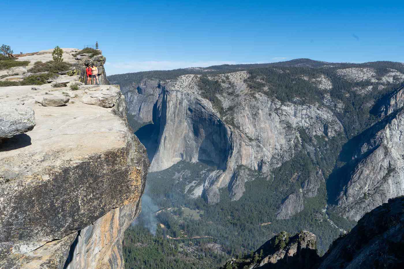
Taft Point in Yosemite National Park is a stunning hike that overlooks the valley on top of sheer cliffs. It is certainly on a short list of the best easy hikes in Yosemite. If features incredible views of El Capitan, Yosemite Falls, the valley, and unique rock formations, cliffs, and fissures.
Quick Navigation:
Trail Map | Trails | Hiking In Winter | Camping | Directions | Pictures
Difficulty – Easy
Distance –2.2 miles (3.5 km)
Height – 7,500 feet (2286 m)
Elevation gain – 200 ft (60 m)
Duration – 2-3 hours round trip
Hike Class: Class 2
Trailhead Location – Sentinel Dome and Taft Point Trailhead
Dogs – Not allowed
Need To Know Information
- A permit is required to enter Yosemite at many parts of the year: https://www.nps.gov/yose/planyourvisit/permitsandreservations.htmhttps://www.fs.usda.gov/recarea/arp/recarea/?recid=8080
- Additional permits are not required to hike this trail unless hikers are spending the night in backcountry camping zones..
- Glacier Point Road is closed during winter, approximately late May through October or November. Be sure to check the road status.
- Glacier Point Road is a groomed cross-country skiing trail during winter when the Badger Pass Ski Areas is open. This PDF has information on the winter trails around Glacier Point.
Trail Map
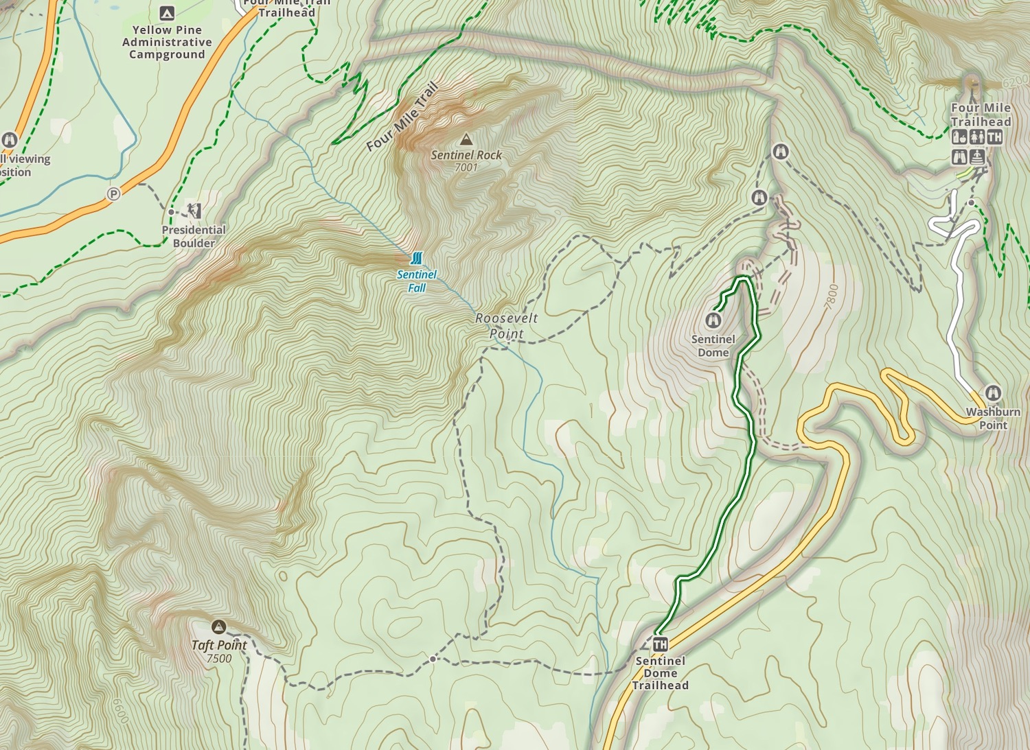
Sentinel Dome and Taft Point Trail Map
Routes
Because Taft Point shares the same trailhead as Sentinel Dome, it is commonly hiked together with both as they are both relatively short hikes with incredible views, and are vastly different. We will cover the distance for combining both below as well.
Taft Point
 Distance – 2.2 miles (3.5 km) round-trip; 2 hours,
Elevation Gain – 200 ft (60 m) elevation gain
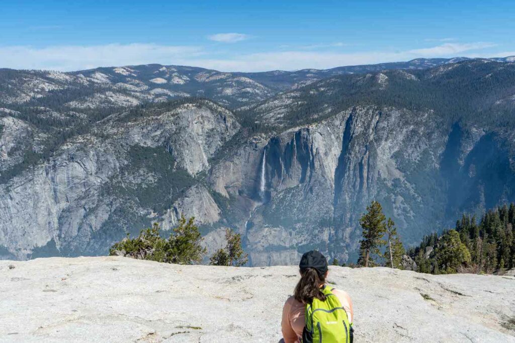
Taft Point has incredible views of Yosemite Valley, particularly El Capitan and Yosemite Falls. Once hikers get near Taft Point, they find dramatic cliffs, narrow fissures (large cracks/fractures in the rock), and these fishers and cliffs drop over 1,500 feet in several cases.
The views are incredible, and the rock formations are very unique.
Hiking Sentinel Dome
Difficulty – Easy
Distance – 2.2 miles (3.5 km)
Elevation gain – 430 ft (131 m)
Duration – 2-3 hours round trip
Hikers begin at the trail by the bathrooms at the Sentinel Dome & Taft Point trailhead.
The trail is easy to follow, and well marked. The trail takes you through some beautiful forest. As hikers approach the final ascent of the dome, a couple other trails split off to the right. If hikers simply stay left, they will make their way on the most direct trail to the summit.
Hiking Sentinel Dome & Taft Point
Difficulty – Intermediate
Distance – 4.9 miles (7.9 km)
Elevation Gain – 1,000 ft (300 m)
Duration – 3-4 hours round trip
Anyone looking to take these two short hikes and turn them into one intermediate hike should do both Taft Point and Sentinel Dome. Leaving from the trailhead, hikers can choose to go to either the Dome, or Taft Point first. Both are very unique and stunning in different ways, but highly recommended. This loop can be lengthened via the Pohono Trail to Roosevelt Point, but the quickest way to do the loop is to just walk back to the trailhead and continue on to either Sentinel Dome or Taft Point in an out-and-back method for each hike.
Hiking in Winter
Refer to trail closures and winter hiking info here.
Camping Information
Nearby lodging and campground information can be found here.
And getting backcountry/wilderness camping permit info can be found here.
Weather
Here is a detailed weather forecast for the area:
Yosemite Valley, CA
This Afternoon
Partly sunny. High near 50, with temperatures falling to around 45 in the afternoon. East wind around 0 mph.
Tonight
Mostly clear, with a low around 37. East northeast wind around 5 mph.
Monday
Sunny. High near 50, with temperatures falling to around 45 in the afternoon. North wind 0 to 5 mph.
Monday Night
Mostly clear, with a low around 37. East northeast wind 5 to 10 mph.
Tuesday
Sunny, with a high near 50. North wind 0 to 5 mph.
Tuesday Night
Mostly clear, with a low around 36. North wind 0 to 5 mph.
Wednesday
Sunny, with a high near 51. North northeast wind 0 to 5 mph.
Directions
Directions to Sentinel Dome and Taft Point Trailhead:
Additional Pictures
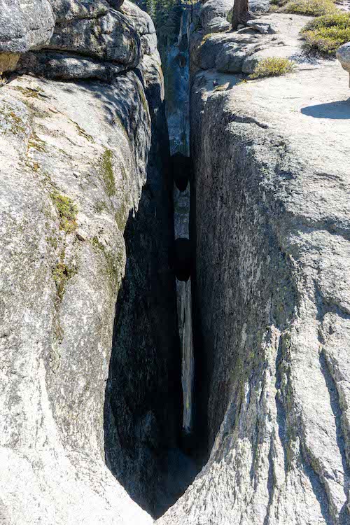
A fissure near Taft Point
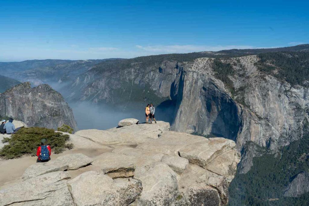
Taft Point Views
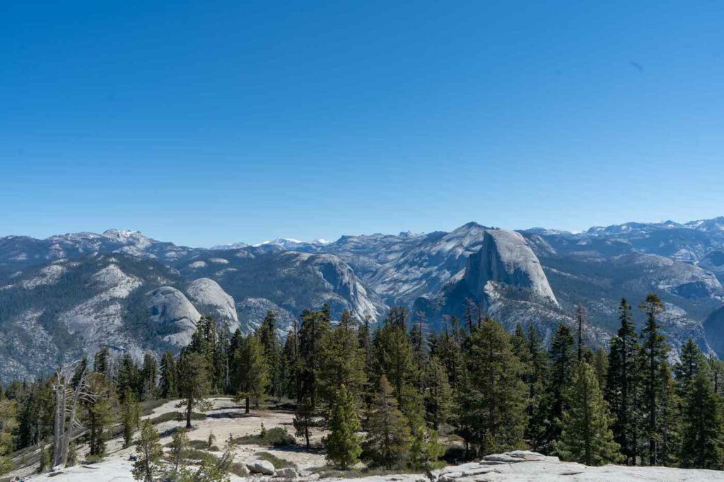
Views from near the top of Sentinel Dome
Views from Sentinel Dome
Max DesMarais is the founder of hikingandfishing.com. He has a passion for the outdoors and making outdoor education and adventure more accessible. Max is a published author for various outdoor adventure, travel, and marketing websites. He is an experienced hiker, backpacker, fly fisherman, backcountry skier, trail runner, and spends his free time in the outdoors. These adventures allow him to test gear, learn new skills, and experience new places so that he can educate others. Max grew up hiking all around New Hampshire and New England. He became obsessed with the New Hampshire mountains, and the NH 48, where he guided hikes and trail runs in the White Mountains. Since moving out west, Max has continued climbed all of the Colorado 14ers, is always testing gear, learning skills, gaining experience, and building his endurance for outdoor sports. You can read more about his experience here: hikingandfishing/about