Twin Peaks sit just outside Salt Lake City. They loom about 7,000 feet over the valley and are visible from just about anywhere. Summiting these peaks takes quite a bit of work due to the elevation gain, and are the first major peaks as part of the WURL. Here’s everything you need to know about getting to the top of these summits.
Quick Navigation:
Trail Map | Trails | Hiking In Winter | Camping | Weather | Directions | Pictures
Difficulty – Extreme
Distance – 8.5 miles round trip (13.7 km)
Height – 11,328 feet (3453 m)
Elevation gain – 5,299 feet (1615 m)
Duration – 8-10 hours (book time)
Trailhead Location – Broads Fork Trailhead (Mill B South) – Secondary Trailhead: Ferguson Canyon Trailhead
Dogs – Not allowed
Need To Know Information
- Dogs are not allowed in Big Cottonwood Canyon or anywhere on this peak.
- There are a two common routes. The easiest route is from Broad Forks, and the second most common route is from Ferguson Canyon, which is the first part of the WURL.
- Both routes require greater than 5,000 feet of elevation gain, as well as difficult trail and scrambling. This hike is not beginner friendly because of this.
- The Broads Fork Trailhead shares the same parking lot as Lake Blanche. So there are tons of cars parked filling up the parking lots, and then parking along the road both before and after the big bend. Be sure to park so that your car is fully outside the white lines if parking on the side of the road. These lots often fill up at around 7 am on weekends.
My Experience
My first time summiting Twin Peaks was from Ferguson Canyon in preparation for the WURL. Since then, I have summited Twin Peaks several times, both from Ferguson Canyon, and from the Broad Forks trailhead. Every time, this hike is pretty brutal due to the elevation gain, but the views never disappoint. If you are looking to summit these peaks the easiest way, I highly recommend starting at Broads Fork (Mill B South) trailhead, and if you are looking to practice for the WURL, you should start from Ferguson Canyon.
Trail Map
Here is a link to the primary trail route from Broads Fork (Millcreek Canyon)
Here is a link to the trail route from Ferguson Canyon – This is the start of the WURL
Routes
Twin Peaks Via Broads Fork
Distance – 8.5 miles round trip (13.7 km)
Height – 11,328 feet (3453 m)
Elevation gain – 5,299 feet (1615 m)
Trailhead Location – Broads Fork Trailhead (Mill B South)
This route, while not easy by any means, is the easiest route to the summit. Hikers grab the Broads Fork trail from the parking lot and follow a well traveled and moderate incline trail through the forest. It is easy hiking and easy to follow until hikers get 2.1 miles in and reach the first “junction”. The trails are not marked, nor maintained after this point. The trail naturally enters a clearing where hikers can see the basin that sits below Twin Peaks.
Hikers should stay left towards the center of the basin, rather than cutting right slightly upwards. This right turn is an alternate route that is more steep, and takes hikers along lots of loose rock.
Staying left and finding your way through the basin and eventually head up the loose rock and boulder field to the saddle between Twin Peaks and Sunrise Peak. Once reaching the saddle, hikers turn right and head up the steep route to Twin Peaks summit. This part of the trail will require scrambling and some route finding along an intimidating cliff section.
If you are interested in this route, we have created a GPX route of it here.
Twin Peaks Via Broads Fork Alternate Route
Distance – 7.73 miles round trip (12.4 km)
Height – 11,328 feet (3453 m)
Elevation gain – 5,341 feet (1628 m)
Trailhead Location – Broads Fork Trailhead (Mill B South)
This route is a bit shorter and more direct, but will likely take most people longer because of the more difficult trail. Once hikers reach the open basin about 2.1 miles in, they stay right on the unmarked trail and follow it as closely as possible and begin scrambling up about 2,000 feet of loose rock and boulders to the ridge between Twin Peaks and Storm Mountain.
Once hitting the ridge, there is a lot of scrambling and elevation gain left to gain the summit of Twin Peaks. Once hitting the saddle, hikers are also coinciding with the WURL here. For an adventure, a great loop is going up this way, and heading down the regular broad forks approach, or turning this into a larger loop, and heading towards Mount Superior on the ridgeline.
If you are interested in this route, we have created a GPX route of it here.
Twin Peaks Via Ferguson Canyon
Distance – 10.2 miles round trip (16.4 km)
Height – 11,328 feet (3453 m)
Elevation gain – 6,902 feet (2104 m)
Trailhead Location – Ferguson Canyon Trailhead
The route from Ferguson Canyon is pretty brutal! But, it is very commonly done because this is the first section of the WURL. Hikers begin by hiking along the well traveled and maintained trail through Ferguson Canyon. The trail quickly begins ramping up and getting steeper. The brush continues to get thicker as you ascend further, and eventually, hikers hit a boulder field to hike across, and find their own path through the forest up to the saddle.
From here, hikers have their first scramble to the first summit of the WURL, and simply stay along the ridge all the way to the summit of Twin Peaks. This section features several scrambling sections, very steep cliffs, loose rock, and incredibly beautiful views. Route finding is relatively easy, but there is often no clear path in most places.
If you are interested in this route, we have created a GPX route of it here.
Hiking in Winter
This is a common backcountry skiing zone, but because of the extremely high avalanche dangers, this zone should only be done by those with experience in avalanche terrain. This is not a trail to be attempted by anyone without substantial winter mountaineering experience. You can read the current avalanche forecasts on the Utah Avalanche Center website.
Camping Information
Camping must be at least 1/2 mile off of any road, and 200 feet from any trails, water, or developed areas. These trails are either in National Forest, or Wilderness, so camping is certainly an option to break up the hike.
Weather
Here is a detailed weather forecast for the area:
Granite, UT
Today
Sunny. High near 32, with temperatures falling to around 26 in the afternoon. North northwest wind 2 to 6 mph.
Tonight
Partly cloudy, with a low around 20. Northeast wind around 5 mph.
Monday
Mostly sunny. High near 35, with temperatures falling to around 29 in the afternoon. North wind 2 to 6 mph.
Monday Night
Partly cloudy, with a low around 20. Northeast wind around 5 mph.
Tuesday
Sunny, with a high near 31. Northwest wind around 5 mph.
Tuesday Night
Mostly clear, with a low around 19.
Wednesday
Sunny, with a high near 28.
Directions
Additional Pictures
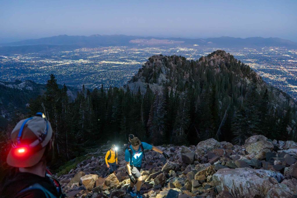
Ascending Ferguson Canyon looking back at the city below.

Views of the ridge heading to Twin Peaks from Ferguson
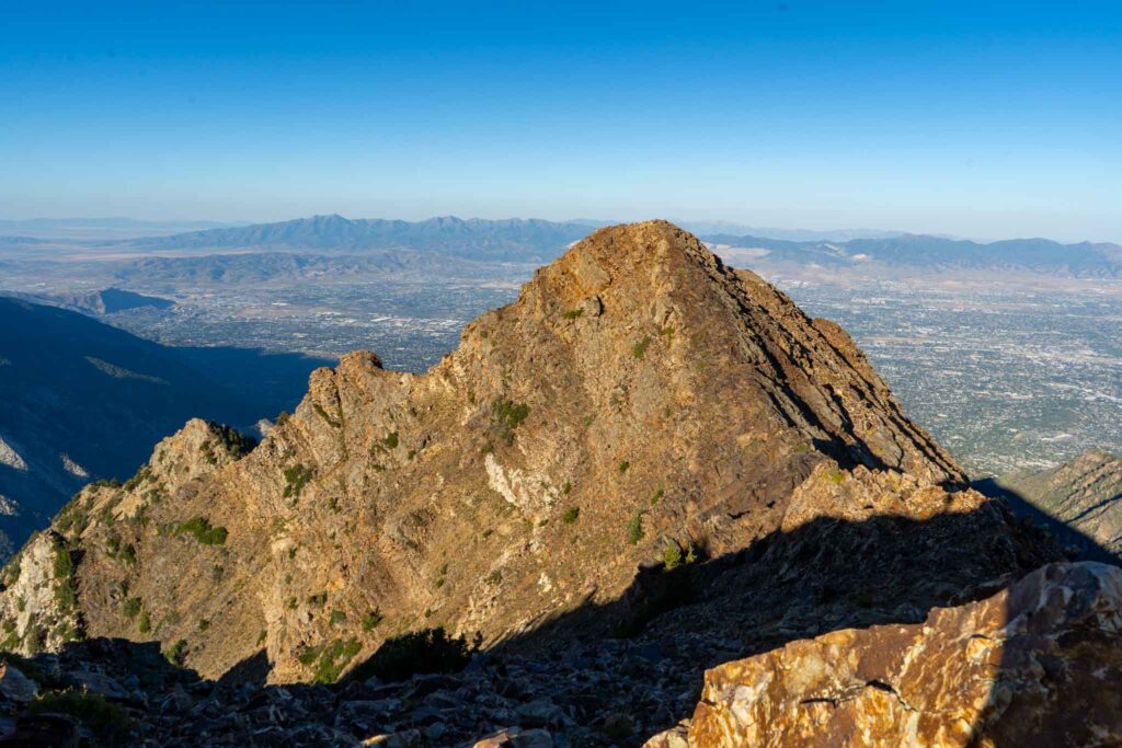
Twin Peaks West as seen from Twin Peaks East

Broads Fork saddle as seen from Dromedary Peak
Max DesMarais is the founder of hikingandfishing.com. He has a passion for the outdoors and making outdoor education and adventure more accessible. Max is a published author for various outdoor adventure, travel, and marketing websites. He is an experienced hiker, backpacker, fly fisherman, backcountry skier, trail runner, and spends his free time in the outdoors. These adventures allow him to test gear, learn new skills, and experience new places so that he can educate others. Max grew up hiking all around New Hampshire and New England. He became obsessed with the New Hampshire mountains, and the NH 48, where he guided hikes and trail runs in the White Mountains. Since moving out west, Max has continued climbed all of the Colorado 14ers, is always testing gear, learning skills, gaining experience, and building his endurance for outdoor sports. You can read more about his experience here: hikingandfishing/about
Epic Morning With Goats!
Had an epic morning. No one on trail, no one on the entire ridge all the way to Catherine’s pass. Surprisingly hot! We hit the summit in about 3.5 hours during our WURL attempt from the Ferguson trailhead.
Twin Peaks from Ferguson - Caught In Lightning
Day started out perfect. We had weather coming in around 2 PM, but at around 11 am we saw clouds in the distance. We decided to bail down into Lake Blanche as we planned to go from Ferguson Canyon to Alta.
Scary bail as lightning began hitting the ridges around us and the pouring rain got us soaked, and made the downclimbing scary. Gotta be careful of weather on these ridges.
Awesome day summiting Twin Peaks from Broads Fork
Awesome day, did a great loop up broads fork and down lake blanche after summiting twin peaks and taking the ridge! The drop down into blanche is ugly FYI – rather avoid if you can!