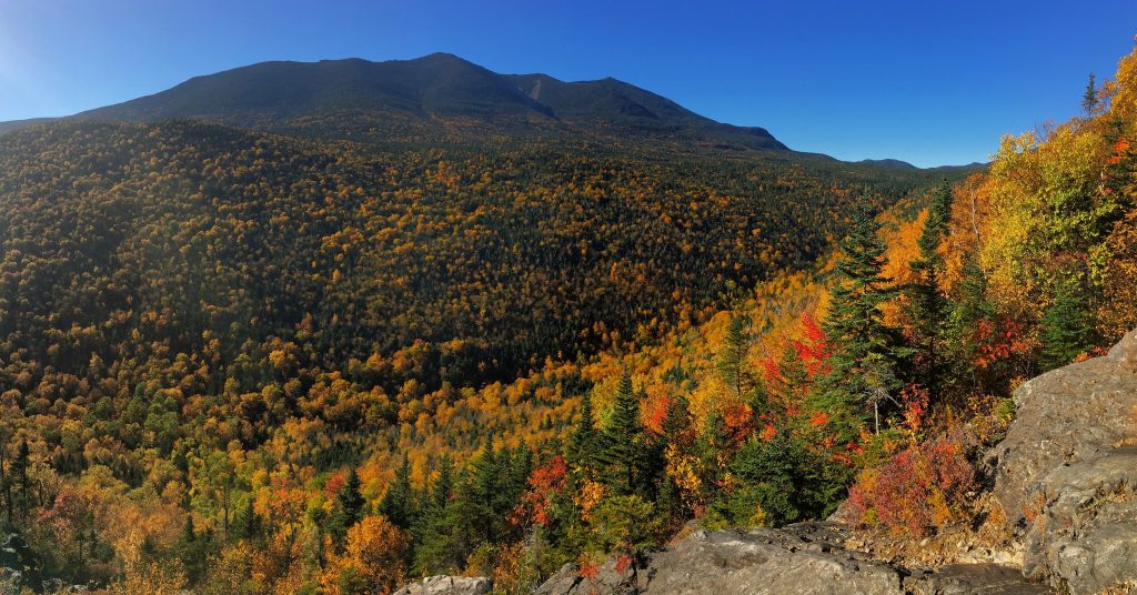
Owl’s Head is probably the hardest to get to single 4,000 foot peak in the White Mountains of New Hampshire. The quickest route to the summit is 9.1 miles right into the heart of the Pemigiwasset Wilderness. It features a lot of flat hiking from the Lincoln woods trail, but ends with a quick and steep ascent on the rockslides on Owl’s Head that face the east side of Franconia Ridge. Though this is a long hike, the views on the slide are fantastic, and the Lincoln Brook Trail is a beautiful path along the river with gorgeous rock formations. Camping is a fantastic option here.
Height: 4,025 feet
Distance: 18.2 miles
Difficulty: Difficult
Elevation Gain: 2,992 feet
Hike Time: 6-10 hours
Trail Map
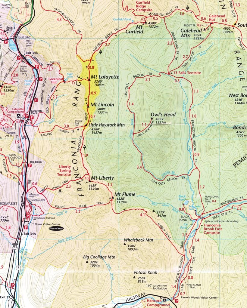
Trails
Lincoln Woods Trail
This trail begins by crossing an incredible bridge over the East Branch of the Pemigewasset River and continues on very flat ground for 2.6 miles until you reach the bridge crossing Franconia Brook. The trail goes along an old logging railroad, so it is flat, wide, and features old railroad ties. You will take a left turn onto the Franconia Brook Trail.
Lincoln Brook Trail
After taking a left onto the Franconia Brook Trail towards the Lincoln Brook trail, you will continue on relatively flat ground for 1.7 miles before turning left onto the Lincoln Brook Trail. This trail goes along the beautiful Lincoln brook, and provides a lot of space for potential stealth campsites, and many stopping points for river watching or taking a dip.
Owl’s Head Path
The Owl’s Head path is a quick 1.1 miles up to the summit. A portion of this trail is a rock slide with very loose rocks that can be difficult to climb. Caution is recommended here. The views of Franconia Ridge are fantastic from this trail.
Bushwack (Avoiding the river crossings) via the Black Pond Trail
Hikers can choose to avoid the major river crossings, that may involve taking off boots with relatively high water on the Lincoln Brook Trail. Hikers can take the .8 mile black pond trail and bushwack towards the Lincoln Brook Trail. It meets up with Lincoln brook around 1.2 miles later just after the toughest river crossing. This route is less traveled and not maintained, so travel can be difficult. It does however save .5 miles or more. When bushwacking, it is always important to know what you are doing. Carry a map and compass.
The Summit Of Owl’s Head
If you are a peak bagger, or just want to make sure you touch the actual summit, you must continue along the summit on a not so well traveled trail. You will find a Cairn at the actual summit. It can be a little difficult to find, and is slightly longer than you expect from the real trail (Between .1 and .2 miles).
Directions
Directions to Lincoln Woods Trailhead:
Other Routes
You can access Owl’s Head from the north side of the Pemi Wilderness from various trails. This peak is often summited by hikers doing a “half pemi loop”. If you have any questions about going from the north directions, let us know and we can help out.
Weather Forecast
Lincoln, NH
Tonight
Isolated snow showers after 3am. Partly cloudy, with a low around 13. Northwest wind around 10 mph.
Monday
Isolated snow showers. Partly sunny, with a high near 22. Northwest wind 5 to 10 mph. Chance of precipitation is 20%.
Monday Night
Isolated snow showers. Mostly cloudy, with a low around 16. Northwest wind 5 to 10 mph.
Tuesday
Isolated snow showers. Partly sunny, with a high near 23. Northwest wind 5 to 10 mph. New snow accumulation of less than half an inch possible.
Tuesday Night
Mostly cloudy, with a low around 12. West wind 5 to 10 mph. New snow accumulation of less than half an inch possible.
Wednesday
Isolated snow showers after 1pm. Partly sunny, with a high near 23.
Wednesday Night
Isolated snow showers before 7pm, then snow. Cloudy, with a low around 21. Chance of precipitation is 100%.
Max DesMarais is the founder of hikingandfishing.com. He has a passion for the outdoors and making outdoor education and adventure more accessible. Max is a published author for various outdoor adventure, travel, and marketing websites. He is an experienced hiker, backpacker, fly fisherman, backcountry skier, trail runner, and spends his free time in the outdoors. These adventures allow him to test gear, learn new skills, and experience new places so that he can educate others. Max grew up hiking all around New Hampshire and New England. He became obsessed with the New Hampshire mountains, and the NH 48, where he guided hikes and trail runs in the White Mountains. Since moving out west, Max has continued climbed all of the Colorado 14ers, is always testing gear, learning skills, gaining experience, and building his endurance for outdoor sports. You can read more about his experience here: hikingandfishing/about